This section describes the display options for the map being viewed. These options are saved for each project.
Available options
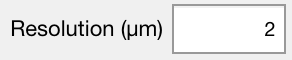
Set the map resolution corresponding to the pixel size, also known as the step size on EPMA instruments. The default value is 20 µm (arbitrary). The resolution value is automatically calculated from the map coordinates defined in Standards.txt when internal standards (spot analyses) are imported.

Activate and display the scale bar using the pixel size defined in Resolution. Two options are available from the drop down menu: white (default) or black.

The Rotate View by 90° button adjusts the orientation of the map. The rotation angle is displayed next to the button and can be set to 0 (default orientation), 90, 180 or 270. Note that some viewing features, such as drag to zoom, are not available when the view is rotated.
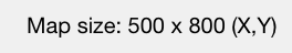
Shows the size of the map. Format: X x Y corresponding to columns x rows
Documentation in XMapTools
The last version of the documentation is provided below:
Was this helpful?
3 / 1